
")
")
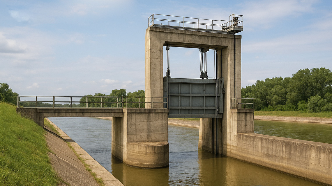
Ustava Novi Bečej (Magistral Canal km 146.66)
The Ustava Novi Bečej was built as a structure for releasing water into the primary canal network to supply Banat with water, as well as for discharging excess water from the Banat section of the canal system into the Tisa River.
It is located on the intake–outflow branch of the Magistral Canal, in the immediate vicinity of the Tisa, enabling the release of large quantities of water. Its importance is even greater for discharging high waters from northern and central Banat.
The Ustava is a massive reinforced-concrete structure with a single opening. The segment gate is a closed steel construction operated by a mechanism driven by two chain hoists. The drive is electric, with manual operation as backup.
Using the segment gate, the inflow of water is regulated as needed, relying on gravitational flow created by the backwater formed by the Tisa Dam.
The Ustava was completed in 1971.
Novi Bečej Ship Lock (Canal Lock) – Magistral Canal km 146.00
This lock enables the passage of vessels between the Tisa River and the Magistral Canal. It is located on the navigational branch of the canal network, near Novi Bečej.
The lock is built as a massive structure with metal sluice gates. It is a single-stage lock with one chamber and gates that can retract into niches. Structurally, it consists of an upstream head, the lock chamber, a downstream head, a guiding structure, and an approach area.
Its dimensions match those of the lock at the Tisa Dam. Construction was completed in 1974, and by 1975 navigation through the lock had begun, with the first gravel-loaded barges reaching Kikinda.
Construction Level of the Primary Canal Network
According to general assessments, the construction level of the primary canal network allows full and intended use according to the original project.
It enables:
- drainage
- improved flood protection
- irrigation
- fishery development
- industrial water supply
- acceptance of wastewater
- navigation
- recreation and tourism
The primary canal network consists of major canals and hydraulic structures, including sluices, locks, pumping stations, and other supporting infrastructure.
Magistral canals in Banat and Bačka have a total length of 694 km and form closed basins separated by hydraulic structures. Water regimes within these basins are controlled within designed limits. There are 12 such basins, all fully operational.
The system includes:
- 694 km of canals
- 20 sluices (15 new and 5 old)
- 17 locks (12 new, accommodating vessels up to 1,000 tons)
- 6 pumping stations for water supply and removal of excess water
Functions of the Primary Canal Network
As a multifunctional system, the primary canal network serves:
- drainage of excess water
- flood protection and improved flood-defense conditions
- irrigation
- fishpond water supply
- water supply for industry and settlements
- acceptance of treated wastewater
- navigation
- forestry
- recreation, tourism, and water sports
- utilization of hydro-energy potential
Organizationally, the network includes not only newly built or reconstructed canals but also all natural watercourses intersected by the system, forming a unified water-management whole.
To ensure the network functions as intended, two conditions must be met:
- all structures must be maintained in operational condition
- water regimes must be actively managed at all times
The current degree of utilization is high in some sectors but significantly lower in others, mainly due to technical and economic constraints requiring attention in the future.
Drainage
The collection and drainage of internal waters from vulnerable areas are largely gravitational and represent the most important function of the canal network, currently utilized to a very high degree. Before the construction of the primary canal network, drainage was inefficient and significantly more expensive due to the high energy consumption required for pumping.
New and reconstructed drainage systems have been built across about two-thirds of the designated area within the canal network’s catchment. Drainage benefits are substantial and almost fully realized, as most systems connected to the canal network are already constructed.
Construction of the canal network greatly improved drainage conditions across both Banat and Bačka. Large, deep recipients without backwater now allow gravitational inflow of excess water to a much greater extent.
Drainage has always been vital for Vojvodina and Banat due to geographic and natural conditions. Today, large areas are drained, making hundreds of thousands of hectares arable.
The degree of utilization of the canal network for drainage is extremely high, enabling economic development across a wide region.
In our area, drainage systems have mostly been built in low-lying fields, directed toward the canal network, with some flowing gravitationally into it.
Protection from High Waters (Flood Defense)
Compared to conditions before the canal network was built, flood-defense capabilities on all intersected watercourses have significantly improved. The risk of flooding has been greatly reduced. In Banat, the canal network intersects and connects all watercourses, enabling the evacuation of high waters through sluices. This reduces peak water levels and the risk of flooding settlements and agricultural areas—one of the system’s most valuable functions.
External waters—large inflows—reach the canal network from surrounding territories. The system intersects watercourses coming from neighboring countries (such as the Zlatica, Begej, and Tamiš), positively affecting their water regimes compared to the pre-canal-construction period.
Thus, conditions for improved high-water discharge have been created, strengthening flood protection on these watercourses.
In our region, in several recent years, flood-defense operations were conducted on parts of the Magistral Canal and Kikinda Canal during high-water events. Defense passed without major consequences due to regular maintenance of embankments and hydraulic structures within the flood-defense system.
For the same reasons, other parts of the canal network are also exposed to high waters and are included in the Flood Defense Plan of Vojvodina, placing them on par with major watercourses.


Comments